
地図には、世界中の承認済みの釣果が並びます。他の人の位置は、あなたの会員ランクに応じてぼかされます。
The map shows approved catches from all over the world. Other people's locations are blurred according to your tier.
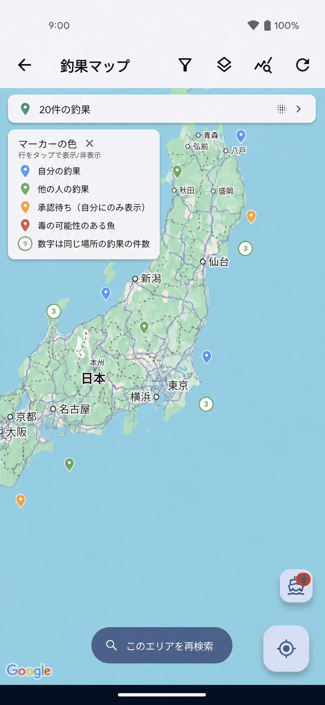
1. マーカーの色を覚える
- 青 — 自分の釣果
- 緑 — 他の人の釣果
- オレンジ — 承認待ちの釣果(自分にだけ見えます)
- 赤 — 毒の可能性がある魚
- Blue — your catches
- Green — other anglers' catches
- Orange — records awaiting review (visible only to you)
- Red — fish that may be venomous
凡例は地図の左上の「?」ボタンからいつでも開けます。同じ場所に釣果が重なると、数字のバッジで件数が出ます。
Open the legend any time from the ? button at the top-left of the map. Where catches pile up in one place, a numbered badge shows how many.
2. 絞り込む
- 凡例の行をタップすると、色(種類)ごとに表示/非表示を切り替えられます
- 右上のフィルタボタンからは、魚種別・月別(1〜12月)でも絞り込めます
- 絞り込み中は、上部のバナーに「表示中 / 全体」の件数が出ます
- Tap a row in the legend to show or hide that colour
- The filter button at the top-right also filters by species and by month
- While a filter is on, the banner at the top shows *shown / total*
絞り込みはその場だけです。地図を閉じるとリセットされます。
Filters apply only while you are there — they reset when you leave the map.
3. マーカーが立つ場所
写真に位置情報(EXIF GPS)があれば撮影地点=実際に釣った場所に、無ければ記録したときの端末の位置に立ちます。あとから自宅で記録しても、写真に位置情報があれば釣った場所に立ちます。
If the photo carries location data (EXIF GPS), the marker goes on where the photo was taken — the actual spot. Otherwise it goes on where your device was when you recorded it. So recording at home later still lands on the spot, as long as the photo has its location.
4. 他の人のスポットを解除する
気になる他の人の釣果は、詳細画面から Fish Token を使って正確な位置を1件ずつ解除できます。価格は魚の希少度と場所の人気で 10〜500 Token の間で決まり、一度解除すればずっと見られます。
On another angler's catch you can spend Fish Tokens to unlock its exact location, one at a time. The price runs from 10 to 500 Tokens depending on how rare the fish is and how popular the place is, and once unlocked it stays unlocked.
投稿者が「自分だけに表示」「ぼかして公開」を選んだ釣果は解除できません。投稿者本人の選択が常に優先されます。
Catches whose owner chose Keep it to yourself or Share it blurred cannot be unlocked. The owner's choice always wins.
5. 海のマップ(Gold 以上)
公式サイトの「海のマップ・海底地形マップ(Web 版)」(/map)でも、会員ランクに関係なく、サインインなし・無料で同じレイヤーを見られます(記録・出船モード・現在地・釣果との重ね合わせはアプリだけです)。
The official website's "Sea Map & Seafloor Map (Web)" (/map) shows the same layers for free, with no sign-in and regardless of tier (recording, Boat Mode, your location and overlaying your catches remain app-only).
地図右上のレイヤーメニュー(標準 / 航空写真を切り替えるのと同じ場所)で「海のマップ」を ON にすると、海上保安庁「海しる」の海洋情報(規制・区域/航路標識・障害物/等深線・底質)を釣果マップに重ねられます。
In the layers menu at the top-right of the map — the same place you switch between standard and satellite — turn on Sea chart to overlay marine information from MSIL, the Japan Coast Guard's Marine Situational Indication Linkages: regulated areas, aids to navigation and hazards, and depth contours with seabed type.
地図に出てくる記号(★の灯台・黒い船形の沈船・黄土色の岩など22種)の意味は、海のマップ(記号の読み方)にまとめてあります。アプリの凡例は等深線の色だけなので、記号を調べたいときはそちらへ。
What every symbol means — the ★ lighthouses, the black ship-shaped wrecks, the ochre rock marks and 19 more — is set out in the sea chart layer, symbol by symbol. The app's own key covers only the contour colours.
6. 海底地形マップ(Gold 以上)
同じレイヤーメニューで「海底地形マップ」を ON にすると、GEBCO の全球水深データにもとづく海底の起伏(深さの色分け+陰影)が海の部分に重なります。陸地は透けるので、地名や海岸線はそのまま読めます。世界中の海に対応しており、日本周辺はより細かいデータで描かれます。
In the same layers menu, turn on Seafloor map to overlay seafloor terrain (colour-coded depth with shaded relief) based on the GEBCO global bathymetry. Land stays transparent, so place names and coastlines remain readable. It covers seas all over the world, with finer data around Japan.
- 海のマップと同時に ON にできます — 等深線や規制区域が地形の上に重なります
- 右下のボタン(グラデーションのアイコン)で深さの色の凡例と出典を開けます
- ズーム3〜12で表示され、それ以上拡大するとぼやけます(データの限界です)
- 岸に近い場所は、海のマップの「等深線・底質」のほうが正確です(日本周辺)— 凡例シートの「等深線を重ねる」から1タップで重ねられます
- It can be on together with the sea chart layer — contours and regulated areas draw on top of the terrain
- The button at the bottom-right (gradient icon) opens the depth colour legend and the source
- It draws between zoom levels 3 and 12; zooming in further just looks softer (the limit of the data)
- Close to shore, the "Depth contours & seabed" layer of the sea chart is more accurate (waters around Japan) — add it in one tap from the legend sheet
海のマップか海底地形マップを ON にしているときは、地図を長押しするとその地点のおおよその水深(参考値・GEBCO_2026)が小さなカードに出ます(出船モードでなくても使えます。× で消せます)。右下の「航海用ではありません」のチップは「−」で1行に畳めます(畳んでも見出しと出典名は残り、タップで戻ります)。地図を回転させたときは右上に方位ボタンが出て、タップで北を上に戻せます。
With the sea chart or the seafloor map on, long-press the map to get the approximate depth (reference value, GEBCO_2026) at that point in a small card — no need for Boat Mode (dismiss it with ×). The *not for navigation* chip at the bottom-right can be collapsed to one line with the − button (the heading and the source names stay; tap to expand again). When you rotate the map, a compass button appears at the top-right — tap it to point north up.
おおよその参考情報であって、航海用ではありません。 約450m格子の推定のため浅場の地形は表現できず、魚探の代わりにはなりません。航海の判断は、海上保安庁の海図と最新の水路通報・航行警報でお願いします。出典は GEBCO_2026 Grid です。
This is an approximate reference, not for navigation. Estimated from a ~450 m grid, it cannot resolve shallow-water terrain and is no substitute for a fish finder. Base navigational decisions on official charts and the latest notices to mariners. The source is the GEBCO_2026 Grid.