
航海用ではありません。 航海の判断は、海上保安庁の海図と最新の水路通報・航行警報でお願いします。到着予想時刻(ETA)・航路の案内・AIS・アンカーウォッチは提供しません。
Not for navigation. Use Japan Coast Guard charts and the latest notices to mariners and navigational warnings for decisions about navigation. No ETA, route guidance, AIS or anchor watch is provided.
1. 始めかた
地図の右下にある船のアイコンのボタン(現在地ボタンのすぐ上)を押すと ON になります。レイヤーメニューの中にはありません。
Tap the boat button at the bottom-right of the map, just above the my-location button. It is not in the layers menu.
押した時点で記録が始まります。 アプリを起動して最初に ON にしたときは、注意事項の全文ダイアログが1回出ます。位置情報の利用を許可していないと開始できず、「位置情報が使えないため出船モードを開始できません」と表示されます。
Recording starts the moment you tap it. The first time you turn it on after launching the app, the full notice is shown once. It cannot start without location access — you will see *Boat Mode cannot start because location is unavailable*.
Gold 未満のときはボタンに鍵のバッジが付き、押すと必要な会員ランクの案内が出ます。
Below Gold the button carries a lock badge, and tapping it explains which tier you need.
2. 画面の読み方
画面の上部に計器(HUD)が出て、走った軌跡が地図に線で残ります。
A heads-up display appears at the top of the screen, and your track is drawn on the map as you go.
- 速度 — ノット表示(km/h も併記)
- 進行方向 — 8方位と角度(例「北東 45°」)。ほぼ停船中(対地速度およそ1ノット未満)や、端末が方位を返さないときは「--」になります(故障ではありません)
- 水深 — GEBCO_2026 にもとづくおおよその参考値
- 経過時間と走行距離
- Speed — in knots, with km/h alongside
- Heading — a compass point and degrees, e.g. *NE 45°*. It reads
--while you are essentially stopped (under about one knot over ground) or when the device reports no heading. That is not a fault - Depth — an approximate reference value from GEBCO_2026
- Elapsed time and distance travelled
右下の現在地ボタンは「自船を追尾」の ON/OFF に変わります(OFF にすると地図を自由に動かせます)。
The my-location button becomes a follow your boat toggle — turn it off to move the map freely.
モード中は、地図の一部が一時的に隠れます=上部の件数バナー・左上の凡例(「?」ボタン)・下中央の「このエリアを再検索」ボタン。釣果のピンと、右上のフィルタ・レイヤー・エリア分析・更新のボタンはそのまま使えます。終了すると元に戻ります。
While the mode is on, three things are temporarily hidden: the count banner at the top, the legend (the ? button) at the top-left, and the *Search this area* button at the bottom-centre. Catch pins and the filter, layers, area-analysis and refresh buttons keep working. Everything returns when you stop.
3. 目的の地点までの方位と距離
画面下の「対象を選ぶ」(「記録を停止」の隣)から、出船地点やマイスポットを選ぶと、そこへの方位・距離が数値と回転ポインタで出て、その地点に強調リングの印が付きます。対象を選ぶとこのボタンは消え、代わりにポインタのカードが出ます(カードをタップで選び直し、× で解除)。
Tap Choose a target (next to *Stop recording*) and pick your departure point or one of your spots. The bearing and distance appear as numbers and a rotating pointer, and a highlight ring marks the point. The button is then replaced by a pointer card — tap it to change the target, or × to clear it.
地図に線は引きません。 経路の案内はしない設計です(航海用ではないため)。
No line is drawn on the map. Route guidance is deliberately not provided (see not for navigation).
出船地点は、記録が始まって最初の位置が取れてから選べます。マイスポットが1件も無いときは、「釣り日和」ボードから登録できる旨が案内されます。
The departure point becomes selectable once recording has started and the first fix has come in. If you have no spots yet, you are pointed to the Fishing Conditions board where you can add them.
地図を長押しすると、その地点の方位・距離・水深が出ます。水深が出るのは長押しで指した地点だけで、出船地点やマイスポットを選んだときの水深欄は「--」のままです。出船モードでなくても、海のマップか海底地形マップを重ねているときは長押しで水深だけが出ます(地図とスポット)。
Long-press the map to get the bearing, distance and depth of that point. Depth is shown only for a point you long-press — it stays -- for a departure point or spot you choose from the list. Outside Boat Mode, a long press still gives the depth alone whenever the sea chart or the seafloor map is on (Map & spots).
4. 記録は画面をまたいで続く
記録中に撮影して釣果を記録したり、図鑑・分析・釣り日和を見に行っても止まりません。ホーム画面に「出船モードで記録中」のカードが出て、そこから一時停止・再開と「地図を開く」ができます。
Taking a photo and logging a catch — or visiting the encyclopedia, analytics or the conditions board — no longer stops recording. A Recording in Boat Mode card appears on the Home screen, where you can pause, resume or open the map.
停止は地図の「記録を停止」から行います。保存するかどうかの選択があるので、入口を地図に一本化しています。
Stopping is done from *Stop recording* on the map. There is a save-or-discard choice involved, so that entry point is kept in one place.
一時停止のあいだは航跡も距離も増えず、最高速度も更新されません。一時停止していた時間は平均速度の計算からも除かれます。航跡は一時停止をまたぐところで区間を分けて描くので、実際には通っていない直線が地図に出ることはありません。
While paused, your track and distance stay put and your top speed is not updated. The paused time is excluded from your average speed, and the track is drawn as separate segments around the pause, so no straight line appears where you did not actually travel.
一時停止中もスリープ抑止は続きます(画面が消えると記録そのものが止まってしまうため)。
The screen is still kept awake while paused — if it turned off, recording itself would stop.
5. 釣行ログに残す
「記録を停止」を押すと、キャンセル/保存せず終了/保存して終了の3択が出ます。
*Stop recording* offers three choices: Cancel, Exit without saving and Save and exit.
| 選択 | 結果 |
|---|---|
| 保存して終了 | 釣行ログに残る。航跡のミニマップ・距離・時間・最高/平均速度と、その時間帯に記録した自分の釣果を一緒に見られる(記録の開始・停止の前後10分を含む時間帯で、釣った時刻から自動的に照合) |
| 保存せず終了 | その航跡は端末からも削除され、釣行ログには残らない |
| キャンセル | 記録はそのまま続く |
| Choice | Result |
|---|---|
| Save and exit | Kept in your trip log with a mini-map of the track, distance, time and top/average speed, together with the catches you recorded during that window — the start and stop plus 10 minutes either side, matched automatically by the time you caught them |
| Exit without saving | The track is deleted from the device and nothing is kept |
| Cancel | Recording simply continues |
釣行ログは、メニュー(左上の3本線)の「釣りに行く」>「釣行ログ」から開きます。記録を保存した直後に出るメッセージの「釣行ログ」からも開けます。地図画面には常設の入口がありません。各記録は詳細画面から個別に削除できます(取り消し不可)。
Open the trip log from the menu (the three lines at the top-left) under *Go fishing* → *Trip log*. You can also open it from the message shown right after you save. There is no permanent entry point on the map screen. Individual trips can be deleted from their detail screen — that cannot be undone.
一覧には各記録の航跡のサムネイル地図が出て、おおよその航行海域が分かります。詳細画面の地図をタップすると全画面で航跡を見られます(短い移動でも形が分かるよう、航跡の範囲に合わせて拡大されます。出船地点=緑・終了地点=赤・その時間帯の釣果=青のピン)。
Each trip in the list shows a thumbnail map of its track, so you can see roughly where you went. Tap the map on the detail screen to view the track full screen — it zooms to fit the track, so even a short trip is legible (green pin = departure, red = end point, blue = catches during the trip).
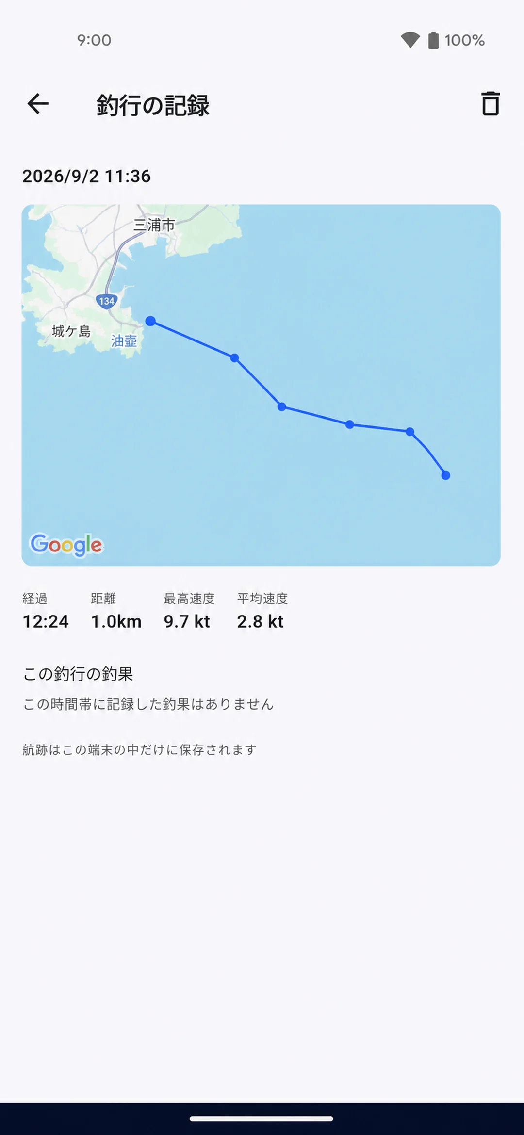
詳細の地図をタップして開く全画面の地図では、釣果マップと同じ右上のレイヤーメニューで標準/航空写真/航空写真+ラベルを切り替えられ、海のマップ・海底地形マップも重ねられます(会員ランクの条件は釣果マップと同じ)。レイヤを重ねていれば長押しで水深が出て、地図を回転させたときは方位ボタンで北を上に戻せます。
The full-screen map you open by tapping the map on the detail screen has the same layers menu as the catch map at the top-right: standard, satellite or satellite with labels, plus the sea chart and the seafloor map (same tier conditions as the catch map). With a layer on, a long press gives the depth, and a compass button resets north when you rotate the map.
6. 保存先と限界
航跡と釣行ログは、この端末の中だけに保存されます。サーバへは送信されません=他の人には見えず、機種変更しても自動では引き継がれません。引き継ぐときは下の「書き出し/読み込み」を使います。
Tracks and trip logs are stored only on this device. They are never sent to the server, so nobody else can see them and they do not move to a new phone by themselves — use export / import below to carry them over.
書き出し/読み込み(機種変更の引き継ぎ): 釣行ログ右上の「⋮」メニューの「全件を書き出す」、または「選ぶ」(チェックリストのアイコン。記録の長押しでも入ります)で複数件を選んで書き出す、詳細画面の共有アイコンで1件だけ書き出す、の3通りがあります。書き出しは共有シートで行き先(他の端末・クラウドドライブ・メールなど)を選びます。新しい端末では釣行ログの「読み込む」からそのファイルを選ぶと保存されます(同じ記録は二度読み込んでも増えません)。⚠️ 書き出したファイルには航跡(位置の履歴)が含まれるので、共有先にはご注意ください。どちらもアプリのサーバは関与しません。
Export / import (moving to a new phone): from the trip log's ⋮ menu choose Export all trips, or tap Select (the checklist icon — a long press on a trip also enters selection) to export several, or use the share icon on a trip's detail screen to export just that one. Export opens the share sheet so you choose where the file goes (another device, a cloud drive, email…). On the new phone open the trip log and choose Import, then pick that file — trips already on the device are skipped, so importing twice does not duplicate anything. ⚠️ The exported file contains your tracks (location history), so take care where you share it. Neither step involves the app's server.
- 釣行ログに残るのは新しい順に50件まで。超えると古い記録から航跡ごと自動的に消えます
- 1回の記録に残せる点は2万点まで。超えると以後は点を採らないため、航跡の線と走行距離がそこで止まります
- 画面を消すと記録が止まります(モード中はスリープを抑止しますが、手動で消灯したりアプリを終了すると止まります)
- 12時間を超えると自動で記録を確定します
- アプリが途中で終了して記録が開いたままになっても、次に地図画面を開いたときに直前までの記録が自動で確定され、釣行ログに保存されます(航跡は約30秒ごとに書き出しているため、終了直前の最大30秒ぶんは残らないことがあります)
- GPS の位置・速度・進行方向には誤差があります
- The 50 most recent trips are kept; older ones are deleted automatically, track and all
- A single recording keeps up to 20,000 points. Beyond that no more points are taken, so the track line and the distance stop there
- Recording stops when the screen goes off. The screen is kept awake while the mode is on, but locking the device or closing the app stops it
- Recording finishes automatically after 12 hours
- If the app closes mid-recording, everything up to that point is saved to your trip log the next time you open the map. The track is written out about every 30 seconds, so up to the last 30 seconds may be missing
- GPS position, speed and heading are all subject to error
7. 水深について
水深は GEBCO_2026(約450m格子の全球データ)にもとづくおおよその値(参考値)です。世界中の海で表示されますが、浅場の地形は表現できません。陸地では「--」になります。
Depth comes from the GEBCO_2026 global grid (cells of about 450 m) and is an approximate reference value. It is available anywhere at sea, but shallow features cannot be represented, and on land you will see --.
魚探の代わりにはならず、浅瀬の警報も出しません。
It is not a substitute for a fish finder and gives no shallow-water warnings.
水深はあくまで目安。
浅場では特に、
実際の海底とはズレるよ。

免責は2段構えです。①アプリを起動して最初に ON にしたときに全文のダイアログが1回出ます②モード中は右下に「航海用ではありません」+水深の出典(GEBCO)の小さなチップが常に出ており、タップすればいつでも全文を読み返せます(HUD の水深セルのタップでも同じ全文が開きます)。海のマップや海底地形マップを同時に重ねているときも、このチップは1枚にまとまり、それぞれの出典が並びます(タップすると全部の注意事項をまとめて読めます)。チップ右上の「−」で1行に畳めます(畳んでも「航海用ではありません」と出典名は残り、タップで戻ります)。
The disclaimer appears twice over: the full notice is shown once the first time you turn the mode on after launching the app, and a small chip at the bottom-right reads *not for navigation* with the depth source (GEBCO) for as long as the mode is on. Tap the chip — or the depth cell in the HUD — to read the full notice again at any time. When the Sea Chart or Seafloor Map is layered on at the same time, the chip stays a single one listing every source (tap it to read all the notices together). The − button at its top-right collapses it to one line — the *not for navigation* heading and the source names stay, and a tap expands it again.
出船モードと海のマップを実画面で紹介する約2分の動画も公開しています(英語ナレーション・英語字幕): 紹介動画を YouTube で見る。アプリからは、出船モードがロックされているときの案内と、アプリ内マニュアル「地図とスポット」章の末尾からも開けます。
There is also a two-minute video tour of Boat Mode and the Marine map, filmed on the real app (English narration and captions): watch the video on YouTube. In the app you can open it from the locked-feature notice for Boat Mode and from the end of the Map & spots chapter of the in-app manual.